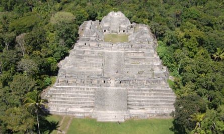
Colorado State University archaeologist Chris Fisher found out about lidar in 2009. He was surveying the ruins of Angamuco in west-central Mexico the traditional way, with a line of grad students and assistants walking carefully while looking at the ground for bits of ceramics, the remains of an old foundation or even a tomb.
He had expected to find a settlement, but instead he happened upon a major city of the Purepecha empire, rivals of the Aztecs in the centuries immediately preceding the Spanish conquest of Mexico in 1519.
The site covered 13 sq km; traditional surveying would have taken years, so he turned to a technology that uses pulses of light to penetrate the forest and ground cover to reveal what lay beneath. “In two seasons we had surveyed only two square kilometres,” Fisher said. But with this new technology – lidar – “we mapped the entire city in 45 minutes.”

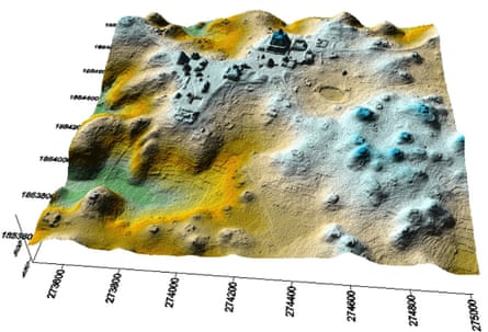
Today, lidar – short for light detection and ranging – is a key archaeology tool that can detect not only buildings but also the remains of roads, agricultural terraces, aqueducts, caves, fences and even boundaries between ancient neighbourhoods.
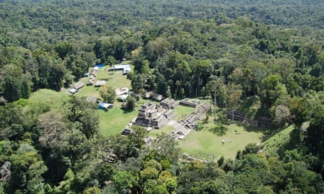
Using hardware based on the ground or on an aeroplane, Lidar can produce images in three dimensions. In the future, drones will probably do most of the surveys. Besides Mexico, lidar has been used to penetrate forest canopy in many countries – among them Belize, Honduras, Guatemala and Cambodia – where the vegetation had been too dense or too troublesome to allow for traditional methods.
“We’ve extended our [lidar] coverage by nearly 2,000 square kilometres,” archaeologist Damian Evans of the French School of Asian Studies said. He is based in the ancient Cambodian city of Angkor, where he is working as project supervisor. “Even our first rough results are showing us things that people have never seen before.”
Lidar came into use in the 1960s, shortly after the laser was invented. It works like radar, calculating distance by measuring the time it takes for a reflected signal to return. But while radar uses radio waves for its signal, lidar uses a pulse of light.
What makes lidar a better choice for many applications, including archaeology, is that the wavelength is about half a micron – tiny relative to radar wavelengths, which are measured in centimetres or decimetres. For details of a relatively small spot on the ground, lidar provides a precision that radar cannot match.
But not at first. To make lidar effective in areas with heavy forest canopy or even low-lying vegetation, engineers needed to increase the pulse rate. The first devices produced about 2,000 pulses, or shots, per second, useless in the jungle because the vast majority of shots bounce off leaves and never reach the ground. Today’s archaeological surveys are routinely carried out at pulse rates up to 600,000 shots per second.
The second feature that defines modern lidar surveys is “stops per shot”. Each shot is scattered by leaves and other vegetation as it travels towards the ground. Modern lidar can count up to four of these “stops” – obstacles – for each pulse. The fourth stop, if there is one, is the ground.
The initial picture a lidar engineer sees is called the “point cloud”, a misty compendium of every pulse and every stop that the machinery has recorded at multiple elevations. Software can help a technician filter out everything but the last stop. The pattern that emerges is the topography below the trees – the ground plan of an archaeological site. And because of variations in the height of objects on the ground, engineers can show the contours, effectively creating maps in three dimensions.
Lidar has myriad applications. Police use it in traffic speed guns; meteorologists use it to examine layers of the atmosphere and to search for concentrations of air pollution; Nasa uses it in docking devices at the International Space Station; the US military uses it to provide quick and detailed terrain mapping for troops.

European archaeologists in the 1970s were among the first to use lidar to tease ancient landscapes from different types of terrain.
“They were mapping old castles and looking at fields,” said scientist William E. Carter, who specialises in the mapping of specific places on Earth at the National Science Foundation’s National Center for Airborne Laser Mapping. “But it was temperate-zone work, almost all farmland.” Nobody using early lidar instruments had been successful at penetrating dense rain forest. “When all you had were 5,000 shots per second, you could spend your life flying over the trees and get nothing.”
Carter first used lidar in the 1980s, working for the US National Oceanic and Atmospheric Administration and the National Geodetic Survey before moving to the University of Florida, which in 2003 became a joint founder of the US National Mapping Center, along with the University of California at Berkeley and the National Science Foundation. In 2010 the centre moved to its current location at the University of Houston.
The centre undertook its first major rainforest assignment in 2009, when University of Central Florida archaeologists Diane and Arlen Chase asked it to survey Caracol, a major Maya city more than 1,000 years ago. By this point, the centre’s aeroplane-mounted lidar was able to pulse 125,000 times per second.
Given Caracol’s dense vegetation, harsh topography and lack of access, “we were tired of doing foot survey”, Diane Chase said. “We wanted the full extent of the site.” On foot, structures in the jungle were hard to map, she said, and agricultural terraces were “almost impossible”. Lidar produced the details of a site that covered 200 sq km – an area slightly larger than Washington DC – with agricultural terraces everywhere. “We could study the distribution of reservoirs, housing, roads, markets – all the parts of the city – things we had never seen before.”
Fisher, at Angamuco, and Evans, at Angkor, both heard about the stunning results at Caracol, and both have been surveying with lidar ever since. Evans mounts his hardware in a helicopter for “operational flexibility” because he is expanding his survey north of Angkor in an environment “where we’re 100 miles [160km] from the nearest airport”. The research team sends a pickup truck with fuel for the helicopter to a clearing and “the chopper just touches down”.
In Mexico, Fisher is partnering with a nearby French research team in an expanded survey of the Purepecha area. The region is malpais – “bad country” with thick soil and a lot of rocks – unsuitable for tractors and other modern equipment but good for ancient farmers who had no farm animals and had to sculpt and shape the terrain by hand, he said. “It was a really rich environment,” Fisher said. “They had big garden spaces, reservoirs and terraces. Lidar lets you see it all.”
Each job presents its own challenges. In Cambodia, surveyors frequently have to go carefully through the lidar data, or point cloud, to spot traces of ancient ruins and infrastructure that lie below relatively modern roads, buildings and agricultural fields. In Mexico, the terrain is relatively uncluttered, but the forest cover varies in height, and structures are small and mostly made of the same volcanic stone that underlies the entire area.
“This is the first time we’ve worked in this environment,” said National Mapping Center engineer Juan Fernandez Diaz. “In areas like Belize, Guatemala and Honduras, the tall, denser trees make it easier to pull features from underneath the canopy. When you’re trying to pull small features, the return can get mixed up with shorter vegetation.”
And of course, with ancient ruins, the appetite always grows with the feeding. “The more we do, the more we find,” Fernandez Diaz said. “People always ask, ‘If you lidar something, will you know everything?’ The answer is always ‘no.’”
This article appeared in Guardian Weekly, which incorporates material from the Washington Post


Comments (…)
Sign in or create your Guardian account to join the discussion